THE OHLONE PERIOD (3000 B.C.)
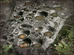 The earliest inhabitants of Richmond were the Ohlone Indians, settling here an estimated 5,000 years ago. They lived a stable and peaceful existence, with a culture based on strong community ties, spiritualism, and rich artistic creativity. The Ohlone were hunters and gatherers and built extensive shell mounds along the Bay. With the coming of the Europeans the Ohlone way of life gradually came to and end and was destroyed.
SPANISH ERA (1772 – 1884)
The first Europeans to visit the city’s future site were the Spanish explorers Pedro Fages and Reverend Juan Crespi who passed through the East Bay in 1772. After Mexico won independence from Spain in 1821, large tracts of land in California were granted to military heroes and loyalists. In 1823, Don Francisco Castro was given 17,000 acres of land in Contra Costa which became known as Rancho San Pablo. The city of Richmond was established on a portion of Castro’s land grant about seventy years after his death.
EARLY INDUSTRY (1885-1901)
In 1895 Augustin S. Macdonald visited Point Richmond and conceived the idea of a transcontinental rail terminal and ferry service, to provide a direct route from Richmond to San Francisco. By 1899 the Santa Fe Railroad established its western terminus in Point Richmond and the Standard Oil Company built its refinery there in 1901.
INDUSTRIAL GROWTH (1900-1940)
 When Richmond incorporated as a city in 1905 it had a population of 2,150 and was already an established industrial town. The city charter was adopted in 1909, and by 1910 the town numbered 7,500.
As the City grew during the 1920s and the 1930s, Richmond’s Downtown emerged as the City’s business and retail center. The elegant Carquinez Hotel (later renamed Hotel Don) opened its doors in 1925 and soon became the center of the City’s social and civic life.
Construction of shipping port terminals began in this period. Tideland filling as part of the harbor dredging in the 1920s made possible the opening of the Ford Motor Assembly Plant and the Felice and Perelli Cannery in 1931. The prohibition era forced the closing of Winehaven, the World’s Largest Winery, built after the 1906 earthquake. The City’s population, meanwhile, had grown from 2,150 in 1905 to 23,600 in 1940.
WORLD WAR II AND THE SHIPYARDS (1940-1945)
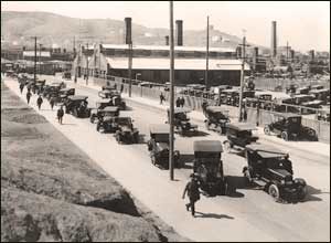
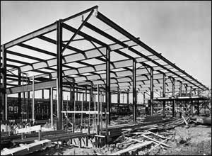
The next chapter was by far the most dramatic and earth-shaking in Richmond’s history. World War II began and the results were explosive growth for the Kaiser Richmond shipyards, one of the biggest wartime shipbuilding operations; large-scale immigration of worker; a ‘boomtown’ atmosphere in Richmond, and profound long-term effects on the City. Richmond’s population increased dramatically from 23,600 in 1940 to over 93,700 in 1943, as tens of thousands of new residents, white and black, migrated from the economically depressed South and Southwest to work in the shipyards.
Much of the new population was housed in temporary structures. Dormitories, demountable houses, and apartment buildings were built; more than 60,000 persons lived in public housing. Many ‘temporary’ housing units remain today.
POSTWAR ADJUSTMENT (1945-1960)
 At war’s end, the shipyards closed in 1945 and a far-reaching readjustment began. Industrial production rapidly declined and the population decreased steadily from 101,500 persons in 1947 (a special census count) to 71,900 in 1960.
A number of new industries moved in to occupy vacated shipyard structures. Among them were Kaiser Aircraft, Garwood, Butler, Southwest Welding, Pacific Vegetable Oil, United Heckathorn, and the first of the major warehousing operations, Ford Parts Depot and International Harvester.
The Richmond Redevelopment Agency was formed in 1949 and undertook several redevelopment projects starting in the mid-1950s. The Harbor Gate Redevelopment Project cleared war housing in 1955, thereby providing sites for additional major warehouses for such companies as Safeway and United Grocers.
As new industries arrived, a number of old ones moved out. Ford moved to Milpitas in 1955 and the Pullman Shops closed in 1959. A strong growth in warehousing and distribution and chemical and research facilities was evident among the post-war developments. Throughout this history Standard Oil, now called Chevron, and its subsidiaries, Chevron Chemical and (later) Chevron Research, have grown steadily and have remained the City’s major industry and employer, with the exception of the war-time shipbuilders.
Land annexations by the City between 1953 and 1957 to the northeast and northwest resulted in a geographically much enlarged but barely contiguous city.
MODERN RICHMOND (1960-1995)
Four major developments since 1960 — Marina Bay, Hilltop Mall, the Knox Freeway (I-580), and the Richmond Parkway — have transformed Richmond’s geography as well as its economy.
Starting in the mid-1970s, the Harbour Redevelopment Project on the city’s South Shoreline led to the transformation of the old Inner Harbor Basin (the site of the wartime shipyards) into the Marina Bay development, a 350-acre master-planned waterfront community that will eventually comprise 2,100 residential units, 650,000 square feet of commercial space, several restaurants, a 1,500-berth pleasure boat marina, and a chain of lagoons, parks, and waterfront promenades.
Opening in 1976, Hilltop Mall Regional Shopping Center had a major impact on Richmond’s economy and its old downtown area in particular. Hilltop is a 1.3 million square foot enclosed shopping center located in the northern corner of the City along Interstate 80. Richmond’s downtown business district began to decline in the early 1970s as its major retailers (Macy’s, J.C. Penney’s, Thrifty, and Woolworth’s) all either moved to Hilltop or closed their Richmond operations entirely.
Another major event occurred in 1978 when the proposed Hoffman Freeway (now the Knox Freeway, Interstate 580) was designated as a part of the Interstate freeway system, thereby ensuring its construction. Funding (90% Federal, 10% State) was attained in late 1982, crowning more than 25 years of efforts. Construction began in 1985 and was mostly completed by the end of 1991. The new freeway passes across Richmond’s South Shoreline and connects Interstate 80 with the Richmond-San Rafael Bridge. The freeway provided 7 new interchanges along the South Shoreline, and has made it a very attractive corridor for new high-tech industrial, business parks and commercial development.
The fourth major development transforming Richmond has been construction of the Richmond Parkway, which began around 1990. A ‘drivable route’ along all sections of the Parkway was achieved by the end of 1994. The Parkway is a 7 1/2-mile, four-lane, scenic and landscaped expressway providing a speedy link between the northern edge of Richmond (Interstate 80 at Hilltop) and the City’s southwest corner (the I-580 freeway and the Richmond-San Rafael Bridge). The Parkway is opening up a large, industrially zoned area in northwest Richmond that been historically underdeveloped due to poor access.
POPULATION CHANGES (1960-1995)
The City’s population remained within the 71,000 – 79,000 range from 1960 to 1987, with little new development until the early 1980s. Between 1987 and 1995, however, Richmond’s population grew steadily from 78,900 in 1987 to 93,000 in 1995. This dramatic increase was due primarily to the large number of new homes that were built in the El Sobrante, Hilltop, Brickyard Cove, Marina Bay, and City Center/Downtown areas during that period. The high rate of new housing construction, however, dropped off sharply beginning in 1992.
Two dramatic demographic changes occurred in Richmond’s population between 1980 and 1990. First, the Asian and Pacific Islander population increased by almost 3 times, from 3,600 persons in 1980 (4.9% of the city’s total population) to 10,300 in 1990 (12% of the city total.) Second, persons of Hispanic Origin increased by almost 5,000 in this 10-year period — from 7,700 persons in 1980 (10.3% of the city’s total population) to 12,700 (14.5% of the total.) In the latest census (1990), Richmond’s population was 44% black, 36% White, 0.5% American Indian or Eskimo, 12% Asian & Pacific Islander, and 7.5% ‘Other.’
RICHMOND TODAY
Richmond covers 56 square miles and has a population now estimated at over 100,000. Richmond’s economy is currently undergoing a major transition from its former heavy industrial character toward more ‘high tech’ and light industrial companies, and new business parks accommodating light industrial and ‘office/flex’ land uses. Bio technology, in particular, has developed as an important new ‘niche’ in Richmond’s growing economy. At the same time, the City’s major manufacturers, such as Chevron, have continued to upgrade their Richmond facilities, making major investments to modernize and expand their facilities.
Today, Richmond is a growing maritime, industrial and residential community with a thriving and changing economy, a dynamic business environment, and a strong potential for further growth.
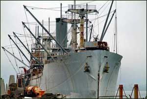
Home of the Rosie the Riveter/World War II Home Front National Historical Park, Richmond played a significant and nationally recognized part in the World War II Home Front. The four Richmond shipyards, with their combined 27 shipways, produced 747 ships, more than any other shipyard complex in the country. Richmond was home to 56 different war industries, more than any other city of its size in the United States. The city grew nearly overnight from 24,000 people to 100,000 people, overwhelming the available housing stock, roads, schools, businesses and community services.
The National Historical Park has the nation’s largest concentration of intact World War II historic structures and sites interwoven within the city of Richmond’s 1940s era historic setting which illustrate a broad spectrum of home front stories.
LOCAL HISTORICAL RESOURCES
 The National Historical Park is the National Park Service’s collection center and coordinator for World War II Home Front oral histories and objects. These collections are in the developmental stages of becoming publicly accessible on-site as well as on the Internet, at www.nps.gov/rori.
The Richmond Museum of History welcomes you to view a glimpse of Richmond; its progress and triumphs. The first Model A Ford built in Richmond, memorable objects from the Kaiser shipyards, ‘horse and buggy’ era vehicles, photographs that date to Richmond’s beginning and domestic artifacts all help to tell Richmond’s fascinating story.
Museum collections are housed and exhibited in a handsome 1910 Carnegie Library building designed by W.H. Weeks. Admission is free to members of the Richmond Museum Association and $2 to non-members and the museum is wheelchair accessible. The Richmond Museum of History is open Wednesday through Sunday from 1-4 p.m. Tours by Appointment.
The Richmond Museum of History
400 Nevin Avenue, Box 1267 Richmond, CA 94802
510-235-7387 | www.richmondmuseumofhistory.org
The Richmond Museum Association has assumed the mission of preserving and restoring the SS Red Oak Victory as an operational vessel. The vessel, a National Memorial Ship, will be developed into a maritime museum focused on the wartime contributions of the residents and workers of the City of Richmond and the shipbuilding ingenuity of Henry J. Kaiser. Visit the website at www.ssredoakvictory.org.